Explore geologic columns. Learn the definition of a geologic column and understand its formation. Find examples of geologic columns and discover its layers.
Geologic Column Definition, Formation & Examples
Table of Contents
Show
Frequently Asked Questions
What is a geologic column and how is it made?
A geologic column is a record of the rock layers in a particular area across geologic time. They are made through observations of the rock, either at outcrops in the field, or of drilling cores in the laboratory. The thickness, features, and age of each layer is determined and depicted in the column.
What is the purpose of the geologic column?
A geologic column is used to better understand the geology of a region. They can be used to determine how the landscaped changed across geologic time, correlated to see the change across a region, or used to pinpoint the location of gas and oil reserves at depth.
What does geologic column mean?
A geologic column in a diagram depicting the rock record in an area, with the oldest rocks on the bottom and the youngest on top.
Table of Contents
ShowA geologic column is a tool used by geologists to understand the rock formations found in a certain area. They are typically presented in a columnar format and differentiated between different parts of geologic time. A geologic column depicts layers of different rocks, with the oldest at the bottom and the youngest at the top. Geologic columns are often also called stratigraphic columns, as stratigraphy is the study of layers in rock and how they relate to geologic time.
What is Geologic Time?
In order to understand the purpose of a geologic column, it is important to know about geologic time. Geologic time is the separation of all earth history in different units of time, with different units relating to different events occurring in geologic history.
 |
Geologic time begins with the formation of the Earth around 4.6 billion years ago. Many geologists refer to this earliest time period as the Precambrian Period, though it is further subdivided into other units of time: the Hadean, Archean, and Proterozoic.
In fact, the Precambrian is simply one of the largest units of time used in the scale, called an eon. Time is then subdivided into eras, periods, and epochs, with epochs being the shortest subdivisions. The separations between these different units are called boundaries. Each boundary is determined based on an event that occurred in Earth history. The boundary between the Precambrian and Phanerozoic is marked by the explosion of visible life (i.e., more complex and multicellular organisms) in the Cambrian Period. Another famous boundary is that between the Cretaceous and the Tertiary, known to scientists as the K/T boundary, which is marked by the extinction of the dinosaurs.
Layers in a Geologic Column
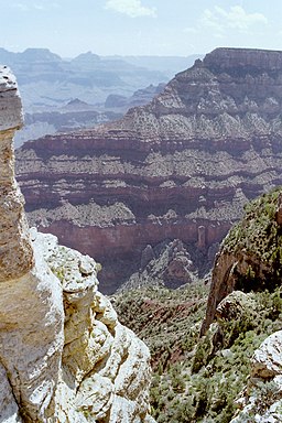
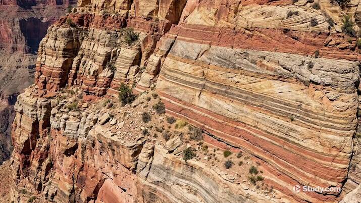
Geologic columns are separated into different layers. These layers often represent different types of rocks, though they can also be used to differentiate between similar types of rocks with different formation behaviors. For example, in limestone, a type of sedimentary rock commonly formed in marine or ocean environments, layers may have different chemical compositions or one layer may have fossils and the others do not. Oftentimes, these differences can be seen in person, such as at the Grand Canyon.
 |
Features of a Geologic Column
Many geologic columns will be accompanied by a legend with different symbols on them. These symbols explain the different features exhibited in the column, such as if a layer has fossils or bedding. Bedding occurs in sedimentary rock and depicts the depositional behavior of the sediments. The thickness of each layer and its place in the time scale are also typically depicted, as is the name of each formation or facies. Facies are the subdivisions of a single formation, often detailing changing landscapes and depositional behaviors for the formation.
Role of a Geologic Column
Geologic columns are most commonly used to determine for an area has changed over geologic time. A single geologic column is used to identify the changing depositional landscape of the specific area it is from.
Geologists also use multiple columns to correlate the changes across a region in space and time. They are able to determine the thicknesses of each formation in different locations and use them to create a cross-section of the changing landscape over time.
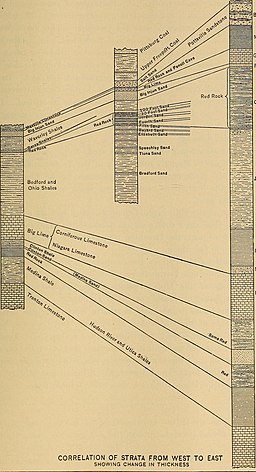 |
For example, if a region was covered with an inland sea, geologists will be able to determine where the shoreline may have been by correlating sandstone formations in several columns. This correlation is also how scientists were able to determine that the continents had once been joined together.
Oil and gas geologists also use columns to help determine which formations contain oil and gas reservoirs for drilling.
Your next lesson will play in
10 seconds
Geologists create geologic columns based on field observations when possible, but also through the drilling of cores and other indirect means. A core is obtained by using a hollow drill to create a cylindrical hole and extract the rock in place so that the different features of the represented layers can be observed.
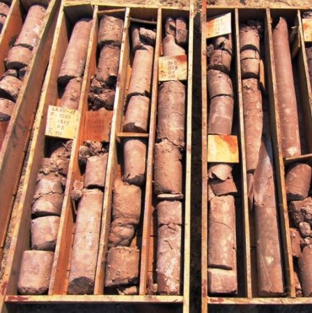 |
The formation of a geologic column is identical whether the data are sourced from the field or a core. A geologist will denote different layers in the observed rock, measure the thickness of each layer, and examine them in detail. Then, they use their detailed notes to create the column, using predetermined symbols to note the features in each layer. If the rock includes fossils, this will help the geologist to date the rock based on the general time the fossilized species were alive on the Earth. If no fossils are found, other features, such as zircon crystals, are dated to determine an accurate age.
Other types of data are also commonly used in geologic columns, depending on what information the geologist is attempting to display. For example, after a core is drilled, instruments that measure the density changes, radioactivity, water saturation, or other features are lowered into the borehole. This practice is called well logging.
 |
Geologic columns have been made for regions around the world and even some areas not on the Earth. To further demonstrate the use and purpose of geologic columns, two examples are described below:
- Grand Canyon
- Cushing Oil Field
Grand Canyon Geologic Column
 |
The geologic column of the Grand Canyon shows the layers that are found there. The bottom of the column contains two different colored units from the Pre-Cambrian. The green unit (Vishnu schist) was formed 1.68 billion years ago. The pinkish-red unit (Grand Canyon Supergroup Rocks) are layered at an angle on top of the green, with ages from 1.2 billion to 740 million years.
These are overlain by flat-laying Paleozoic rocks. Both the green and red units have direct contact with these rocks, which have an age of approximately 542 million years. The contact between the blue Paleozoic and green and red Pre-Cambrian rocks is known as the Great Unconformity due to the missing time and changing contacts between the layers. An unconformity is defined as a break in time in the geologic rock record.
Rocks of the missing age were initially located on top of the Pre-Cambrian ones. In fact, they still exist in the subsurface. The exact reason for the gap in time in these rocks is thought to be caused by a large-scale uplift of the area due to the collision of two tectonic plates, exposing the missing rock to weathering and erosion.
Geologists were able to determine this information by studying the geologic columns at the Grand Canyon and other locations where the Great Unconformity is present.
Cushing Oil Field Geologic column
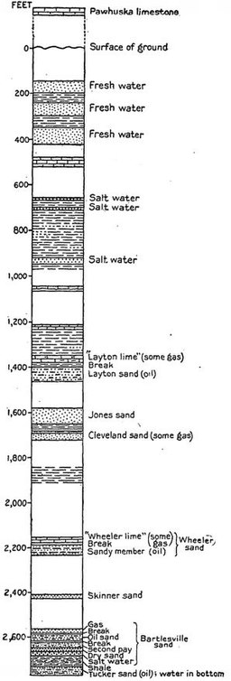 |
In 1914, the United States Government began the inspection of potential oil fields by oil scientists and geologists to determine where oil, gas, and water resources may be located. The Cushing geologic column, from the Cushing oil field in Oklahoma, was one such inspection, completed in 1917.
This column was created based entirely on core observations, and the surface rocks were completely disregarded. In comparison to the Grand Canyon column, this one seems far less detailed. The reasoning for this is simple: the geologist who created this column was interested in different information than those who made the one for the Grand Canyon. In this column, the interest lies primarily in the location of the exploitable oil and gas resources, and the general evolution of the geology in the area is less important.
A geologic column, also called a stratigraphic column, is a tool used by geologists to determine how an area has changed over geologic time. They are diagrams that depict the stratigraphy, or layers of the rock record, with the oldest at the bottom, and the youngest at the top. A column is created based on data collected through direct field observations or indirect means, such as core logs.
Geologic columns can be correlated with each other to show the evolution of a landscape throughout a region and time. In the Grand Canyon, the column depicts the Great Unconformity, which is a large break in time in the rock record. Due to that and other locations of the Great Unconformity, geologists have been able to determine that a large uplift occurred during this period, causing the missing layers to weather and erode. Geologic columns also have other uses, such as determining the location of oil and gas resources, as in the Cushing Oil Field.
Video Transcript
What is a Geologic Column?
Have you ever been to the Grand Canyon? Or seen exposed layers of rock on a bare column in Arizona? The rock there is interesting and often very attractive. This is because it contains striped layers which can be clearly seen. These striped layers are called a geologic (or stratigraphic) column.
 |
A geologic column is a series of layers of different types of rock, placed by the settling of sediments over millions of years when the rock was a seabed. If that rock is now on dry land, it can be seen and studied by humans. These layers are often colorful and dramatically different to each other, and each of the layers represents the kinds of sediments that were most common in that era. Rocks take millions of years to form, and so by looking at the layers of rock and measuring their age, we can figure out what was happening in that area of the earth all those years ago. These layers can go back as far as billions of years in some cases and provide valuable information about the Earth's history.
Example: The Grand Canyon
One of the best and most visited examples of a geologic column is the Grand Canyon. Because the Grand Canyon is so deep, there are a huge number of layers that have become exposed and visible. These layers go back as far as 1.84 billion years.
This diagram shows the layers that can be seen at the Grand Canyon:
 |
The blue part of the diagram shows rocks from the Paleozoic era, a time that stretches from about 542 million years ago to about 251 million years ago. During that time, one of the earth's supercontinents was forming and then breaking apart again, so it was a time of great change on the earth. At the Grand Canyon, a big part of the Paleozoic era can be seen, with a total of 11 individual layers—a mixture of sandstone, limestone, and shale.
Underneath the Paleozoic rocks should be Proterozoic (or Precambrian) rocks from 542 million or more years ago, since the Proterozoic era preceded the Paleozoic time period. But instead, if you look at the lower Grand Canyon, in many places the rock seems to jump straight to 1.68 billion years old—still part of the Proterozoic era, but much further back in time than you might expect. This jump is called the Great Unconformity.
The rocks that are missing between these two periods do exist; they're just buried deeper, behind the rock face, and they're turned at an angle. Why is this? Well, this was a time period more like the Grand Canyon today. It was a period of time when the collision of the Earth's tectonic plates caused this part of the rock to be pushed upwards and exposed to the air—above the water level, just like the Grand Canyon is now. When that happens, no new rock is being formed and instead the rock is being worn away. This violent pushing upwards as two plates collided also caused the rock to become tilted.
All of this and much more was determined by studying and analyzing the rocks we can see along the walls of the Grand Canyon. We can do this all over the world and make amazing discoveries about the history of our planet.
Lesson Summary
A geologic column is a series of layers of different types of rock, placed by the settling of sediments over millions of years, often when the rock was a seabed. Many places that used to be sea beds are now on land and can easily be studied by humans. By looking at these layers, taking rock samples, and analyzing them, we can figure out a lot about the history of the era. When was that rock under the sea? When was it beneath a great forest? There's a lot we can learn.
At the Grand Canyon, the layers of rock stretch back an impressive 1.84 billion years. These include rocks from the Paleozoic and Proterozoic eras. At the start of the Proterozoic layers, there are areas where large periods of history are missing. This is called the Great Unconformity—the result of tectonic activity that caused some of the rock to be worn away and the direction of the layers to be tilted.
Register to view this lesson
Are you a student or a teacher?
Unlock Your Education
See for yourself why 30 million people use Study.com
Become a Study.com member and start learning now.
Become a MemberAlready a member? Log In
BackResources created by teachers for teachers
Over 30,000 video lessons
& teaching resources‐all
in one place.


I would definitely recommend Study.com to my colleagues. It’s like a teacher waved a magic wand and did the work for me. I feel like it’s a lifeline.
Jennifer B.
Teacher

Back

Geologic Column Definition, Formation & Examples Related Study Materials
Explore our library of over 88,000 lessons
Browse by subject